
This map shows the antipodes of each point on the Earth’s surface – the points where the blue and magenta overlap are land antipodes - most land has its antipodes in the ocean. This map uses the Lambert azimuthal equal area projection. The magenta areas can be considered to be opposite reflections of the blue areas but on the inner ‘surface’ of the globe of the Earth.

The same map, from the perspective of the Western Hemisphere. Here the blue areas can be considered to be opposite reflections of the magenta areas but on the inner ‘surface’ of the globe of the Earth, from http://en.wikipedia.org/wiki/Antipodes
Where is YOUR Antipode?
(and some other cool stuff!)
What’s an antipode, anyway? Some of you geographers may know the term, or you may be familiar with it just from reading the journal “Antipode,” with its subtitle “A Radical Journal of Geography.” Or it’s possible you’ve read the journal but never wondered what the name meant! BTW, if you don’t know about this journal, check out their website at http://www.antipode-online.net/default.asp.
“In geography, the antipodes of any place on Earth is its antipodal point; that is, the region on the Earth's surface which is diametrically opposite to it. Two points which are antipodal to one another are connected by a straight line through the centre of the Earth.” From http://www.antipodemap.com/ A line drawn from one place to its antipode passes through the center of the Earth and forms a true diameter.

I really enjoy saying “Antipode,” (pronounced `an-tep-ode, with the emphasis on the first syllable) but even more, I love saying its plural “Antipodes,” (pronounced an-`tip-o-deez, with the accent on the second syllable). The word derives from the Greek words for “opposed” (anti-) and “foot” (pod or pous), or under the feet, opposite. Later on, the Latin usage changed its meaning to “those with feet opposite,” a race of people with feet sticking out of their heads, or people who were inverted and walked on their hands with their legs sticking up in the air, which is what the population on the other side of the world was imagined to be doing. These were common mythical creatures that mediaeval map makers often drew in unknown places to fill up the space. These up-side-down people living at the opposite side of the earth were known as Antichthones, another great word! They took their place on mediaeval maps and marginalia right next to the dog-faced race and the sciapods! "Yonder in Ethiopia are the Antipodes, men that have their feet against our feet." (from the earliest usage in English of the word "Antipodes," from a 1398 translation of Bartholomew of England's "The Properties of Things," a kind of proto-encyclopeadia in 19 volumes written in Latin in 1240).

An interesting thing about the antipodes is that the concept was recognized by the ancient Greeks, (Plato, Aristotle, Plutarch, Strabo, and Diogenes) demonstrating their understanding of a spherical world. In contrast, the early Christians found the idea of antipodes to be absurd, requiring a belief that people in the antipodes were inverted, because, of course, being on the other side of the world and all, they couldn’t possibly stand on their feet like we do! Popes and clergy declared the very notion of antipodes to be heretical, because it would require a belief that, since all people descended from Adam and Eve, descendants of Adam and Eve would have had to have gotten in a boat and traveled over seas to the southern lands, (which were not even known in those times with any certainty to exist). From the point of view of scriptural inerrancy, the fact that the Bible doesn't mention anything about this at all means that it could not be possible.
As a digressive aside, if you are interested in sciapods and other mediaeval beasts, or mediaeval topics in general, pick up a copy of the 2003 book "Baudolino," which tells a fabulous tale involving Prester John (the lost Christian king of the East) and touches upon all the major themes of the day (early 12th century Constantinople): The Fourth Crusade; the troubadours; the legend of the Holy Grail; the rise of the cathedral cities; the position of Jews; the market in relics; the local rivalries that made Italy so vulnerable to outside attack; the perennial power struggles between the pope and the emperor, and the geographic location of the Earthly Paradise. One of the main characters is a sciapod! This mythical epic story is by Umberto Eco, of "Foucault's Pendulum" and "The Name of the Rose" fame. All of them are worth reading.
As a digressive aside, if you are interested in sciapods and other mediaeval beasts, or mediaeval topics in general, pick up a copy of the 2003 book "Baudolino," which tells a fabulous tale involving Prester John (the lost Christian king of the East) and touches upon all the major themes of the day (early 12th century Constantinople): The Fourth Crusade; the troubadours; the legend of the Holy Grail; the rise of the cathedral cities; the position of Jews; the market in relics; the local rivalries that made Italy so vulnerable to outside attack; the perennial power struggles between the pope and the emperor, and the geographic location of the Earthly Paradise. One of the main characters is a sciapod! This mythical epic story is by Umberto Eco, of "Foucault's Pendulum" and "The Name of the Rose" fame. All of them are worth reading.
Back to the Antipodes: By going to the website http://www.antipodemap.com/ you can click on your location on the top map, and the bottom map will show you your antipode. Pretty cool.
Kristen Grady originally sent me the following link to New York City’s antipode, which apparently is somewhere in the ocean southwest of Australia, near an iceberg twice as large as Manhattan. It’s Iceberg B-17B, and it’s a calfed-off part of the Ross Ice Shelf of Antarctica. http://toolserver.org/~geohack/geohack.php?pagename=New_York_City¶ms=-40.716667_N_106_E_scale:10000000_type:city&title=The+Antipodes+of+New%20York%20City

Although it seems strange that our antipode is an iceberg in the middle of an ocean, actually it is about what we would expect. After all, over 70% of the earth’s surface is covered by ocean, and the land masses of the southern hemisphere are particularly skimpy. So the antipode of just about anywhere in the northern hemisphere is likely to be in the middle of the ocean. Less than 4% of the earth’s land masses are antipodal to land.
The way you can calculate your antipodal location by lat-long is to figure that the latitude will be identical, except with the direction reversed. For example, the latitude of the antipode of 40o N will be 40o S. The antipodal longitude will be 180o difference between the two points, with reversed direction, resulting in a location at 74o W having an antipode at 106o E.
x° N/S y° E/W ↦ x° S/N (180 − y)° W/E
x° N/S y° E/W ↦ x° S/N (180 − y)° W/E
Noon at a location is midnight at its antipode, and summer solstice is winter solstice
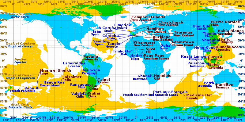
Some cities and towns which are near-antipodes in equirectangular projection. Blue labels pertain to cyan and brown labels pertain to yellow areas. Areas where cyan and yellow overlap (coloured green) are land antipodes.
Find your Center of Gravity
In a similar vein, here is another cool website sent to me by Ms. Grady. With this one, you plug in all the places you have ever lived, and the program calculates the geographical center of all your residences, weighted by number of years or months spent there. You can also do it without weighting it by time. It’s really interesting. I entered all my addresses (if you don’t remember the exact street address, you can just put in city and state), every place I could remember where I spent more than about 2 months of my life. Anywhere I had a “room of my own,” in other words. With all the different places I’ve spent significant time, when I weighted it by years, my center of gravity ended up being along the Old Montauk Highway, Suffolk County, Long Island (NY). This is primarily due to the overwhelming number of years I spent at various addresses in NYC, which pretty much cancels out any years spent anywhere else. I never even lived in Long Island (not that there's anything wrong with it!) When I entered the same addresses without the time weighting, my center of gravity was way up in Maine, for some odd reason! http://www.geomidpoint.com/
The “What Was There” Project
This one is from Lesley Kunikis. Check it out! Some pretty cool stuff!
“Thought this might be of interest to you: http://whatwasthere.com/ The What Was There project was inspired by the realization that we could leverage technology and the connections it facilitates to provide a new human experience of time and space – a virtual time machine of sorts that allows users to navigate familiar streets as they appeared in the past. The premise is simple: provide a platform where anyone can easily upload a photograph with two straightforward tags to provide context: Location and Year. If enough people upload enough photographs in enough places, together we will weave together a photographic history of the world (or at least any place covered by Google Maps). So wherever you are in the world, take a moment to upload a photograph and contribute to history!”

Manhattan on vacation in Chicago
Manhattan travels to other cities...
And another one from Kristen Grady: “This is kind of adorable…” http://www.radicalcartography.net/index.html?manhattan
Scale Comparisons by Bill Rankin. “Inspired a bit by Rem Koolhaas’s Floating Pool project, I wondered what would happen if Manhattan itself decided to take a tour of the oceans, stopping at other cities to refuel and have a good time. Overwhelmed by LA’s vastness, Manhattan decides to stay offshore, while it snuggles in close and completely overwhelms Boston (and inadvertently obliterated Logan Airport).” (From Radical Cartography, Bill Rankin’s website). See Manhattan nestling up to various other cities. So cute!

New York's Bike Requests as a Map of the City's Yuppies
This one sent in by Christopher Herrmann: http://www.theatlanticwire.com/national/2011/09/new-yorks-bike-requests-map-citys-yuppies/42490/
This is about NYC’s new bike sharing program, and apparently the 600 or so bike locations are being decided by web voting. The only problem with this is that the less affluent parts of the city seem to not be voting with the fervor of the more gentrified and yuppified sections, or, dare I say it, those populated by the dreaded hipster. This seeming lack of interest from the less affluent sections of the city denotes, perhaps, less Internet access, less interest in biking, or less disposable money to pay for the yearly bike sharing license.

A Village Street Slips off the Subway Map
This one is from Cordelia Nervi.
“Here's a fun story about the new subway maps, complete with a Lehman shout-out.” http://cityroom.blogs.nytimes.com/2011/10/10/a-village-street-slips-quietly-off-the-subway-map/?hpw
It never ceases to amaze me how things are decided in this world, cartographic decisions included.
It never ceases to amaze me how things are decided in this world, cartographic decisions included.
This comment has been removed by the author.
ReplyDelete
DeleteRecording success in Cryptocurrency, Bitcoin is not just buying and holding till when bitcoin sky-rocks, this has been longed abolished by intelligent traders ,mostly now that bitcoin bull is still controlling the market after successfully defended the $60,000 support level once again and this is likely to trigger a possible move towards $100,000 resistance area However , it's is best advice you find a working strategy by hub/daily signals that works well in other to accumulate and grow a very strong portfolio ahead. I have been trading with Mr Bernie doran daily signals and strategy, on his platform, and his guidance makes trading less stressful and more profit despite the recent fluctuations. I was able to easily increase my portfolio in just 1week of trading with his daily signals, growing my $3000 to $25,000 Mr Bernie’s daily signals are very accurate and yields a great positive return on investment. I really enjoy trading with him and I'm still trading with him, He is available to give assistance to anyone who love crypto trading and beginners in bitcoin investment ,he can also help you recover your lost funds I would suggest you contact him on WhatsApp : + 1424(285)-0682 , Gmail : (BERNIEDORANSIGNALS@GMAIL.COM) or Telegram : @IEBINARYFX for inquiries
from youtube vsauce channel..
ReplyDeleteComputer Aided Automation
I just loved your way of presentation. enjoyed reading this .Thanks for sharing and keep writing. It is good to read blogs like this. As constantly, we appreciate yourself assurance and accept as true within us. webstagram
ReplyDeleteYour Antipodes Map link has been highjacked.
ReplyDeletehttps://bayanlarsitesi.com/
ReplyDeleteEskişehir
Erzincan
Ardahan
Erzurum
6APYH
Ankara
ReplyDeleteBolu
Sakarya
Mersin
Malatya
FOJO
elazığ
ReplyDeletegümüşhane
kilis
siirt
sakarya
3K5211
whatsapp görüntülü show
ReplyDeleteücretli.show
4ELGH
55090
ReplyDeleteKarabük Lojistik
Artvin Evden Eve Nakliyat
Ağrı Parça Eşya Taşıma
Sivas Evden Eve Nakliyat
Antalya Evden Eve Nakliyat
CE97F
ReplyDeleteUşak Lojistik
Trabzon Evden Eve Nakliyat
Sinop Parça Eşya Taşıma
Erzurum Evden Eve Nakliyat
Erzurum Parça Eşya Taşıma
Kırşehir Lojistik
Muş Evden Eve Nakliyat
Karaman Şehirler Arası Nakliyat
Amasya Lojistik
46191
ReplyDeleteEryaman Boya Ustası
Cointiger Güvenilir mi
Mersin Şehir İçi Nakliyat
Batman Şehirler Arası Nakliyat
Kütahya Evden Eve Nakliyat
Uşak Parça Eşya Taşıma
Kocaeli Parça Eşya Taşıma
Tekirdağ Parke Ustası
Bayburt Lojistik
F314B
ReplyDeleteÇerkezköy Çamaşır Makinesi Tamircisi
Ünye Televizyon Tamircisi
Batman Evden Eve Nakliyat
Kucoin Güvenilir mi
Kripto Para Borsaları
Adana Lojistik
Ordu Şehir İçi Nakliyat
Bartın Parça Eşya Taşıma
Tekirdağ Şehirler Arası Nakliyat
D6A2B
ReplyDeleteBitcoin Nasıl Alınır
Gate io Borsası Güvenilir mi
Binance Madencilik Nasıl Yapılır
Facebook Sayfa Beğeni Satın Al
Binance Referans Kodu
Parasız Görüntülü Sohbet
Coin Nasıl Çıkarılır
Telegram Görüntüleme Satın Al
Coin Oynama
503E4
ReplyDeleteBitcoin Nasıl Para Kazanılır
Nexa Coin Hangi Borsada
Milyon Coin Hangi Borsada
Linkedin Takipçi Satın Al
Coin Nedir
Tiktok Beğeni Hilesi
Nonolive Takipçi Satın Al
Star Atlas Coin Hangi Borsada
Onlyfans Takipçi Hilesi
4A051
ReplyDeleteGörüntülü Sohbet Parasız
Mith Coin Hangi Borsada
Spotify Dinlenme Satın Al
Shibanomi Coin Hangi Borsada
Sweat Coin Hangi Borsada
Parasız Görüntülü Sohbet
Kripto Para Kazma Siteleri
Likee App Beğeni Hilesi
Soundcloud Dinlenme Satın Al
THTYJUYJ
ReplyDeleteتسليك مجاري بالاحساء
شركة عزل خزانات dhZwe8ICk7
ReplyDeleteشركة عزل اسطح بالجبيل lKbfmap8VO
ReplyDeleteشركة كشف تسربات المياه بالجبيل K3yuDuluqL
ReplyDeleteشركة تنظيف مجالس بالدمام YYpzE4qA7f
ReplyDeleteمكافحة حشرات 9bG8P6IsIj
ReplyDeleteشركة مكافحة حشرات بخميس مشيط qgsc1HVwU4
ReplyDeleteشركة تسليك مجاري بالدمام Zpw1ZFB1J5
ReplyDeleteشركة تنظيف خزانات RckFXBAAQW
ReplyDeleteصيانة افران YY4JpWo5Fz
ReplyDelete93E330D5A8
ReplyDeleteucuz takipci satin alma
DB7A2D7238
ReplyDeletetiktok takipçi
Referans Kimliği Nedir
Raid Promosyon Kodu
Rise Of Kingdoms Hediye Kodu
Township Promosyon Kodu
Hay Day Elmas Kodu
Eti Mutlu Kutu Kodları
Google Yorum Satın Al
Yalla Hediye Kodu
شركة عزل مواسير المياه بالدمام UlouviAfkf
ReplyDelete